Note: This document is for an older version of GRASS GIS that has been discontinued. You should upgrade, and read the current manual page.
NAME
r.random.cells - Generates random cell values with spatial dependence.KEYWORDS
raster, sampling, random, autocorrelationSYNOPSIS
Flags:
- --overwrite
- Allow output files to overwrite existing files
- --help
- Print usage summary
- --verbose
- Verbose module output
- --quiet
- Quiet module output
- --ui
- Force launching GUI dialog
Parameters:
- output=name [required]
- Name for output raster map
- distance=float [required]
- Maximum distance of spatial correlation (value >= 0.0)
- ncells=integer
- Maximum number of cells to be created
- Options: 1-
- seed=integer
- Random seed, default [random]
Table of contents
DESCRIPTION
r.random.cells generates a random sets of raster cells that are at least distance apart. The cells are numbered from 1 to the numbers of cells generated, all other cells are NULL (no data). Random cells will not be generated in areas masked off.Detailed parameter description
- output
- Random cells. Each random cell has a unique non-zero cell value ranging from 1 to the number of cells generated. The heuristic for this algorithm is to randomly pick cells until there are no cells outside of the chosen cell's buffer of radius distance.
- distance
- Determines the minimum distance the centers of the random cells will be apart.
- seed
- Specifies the random seed that r.random.cells will use to generate the cells. If the random seed is not given, r.random.cells will get a seed from the process ID number.
NOTES
The original purpose for this program was to generate independent random samples of cells in a study area. The distance value is the amount of spatial autocorrelation for the map being studied.EXAMPLES
Random cells in given distances
North Carolina sample dataset example:g.region n=228500 s=215000 w=630000 e=645000 res=100 -p r.random.cells output=random_500m distance=500
Limited number of random points
Here is another example where we will create given number of vector points with the given minimal distances. Let's star with setting the region (we use large cells here):g.region raster=elevation g.region rows=20 cols=20 -p
r.random.cells output=random_cells distance=1500 ncells=20 seed=200
r.to.vect input=random_cells output=random_points type=point
Additionally, we can use v.perturb module to add random spatial deviation to their position so that they are not perfectly aligned with the grid. We cannot perturb the points too much, otherwise we might seriously break the minimal distance we set earlier.
v.perturb input=random_points output=random_points_moved parameters=50 seed=200
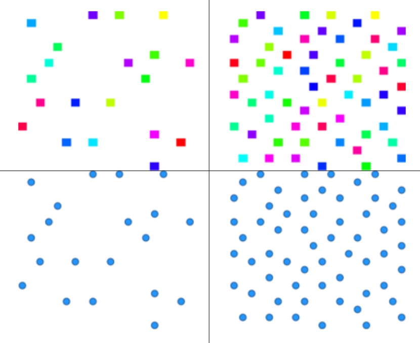
Figure: Generated cells with limited number of cells (upper left), derived vector points (lower left), cells without a count limit (upper right) and corresponding vector points (lower right)
REFERENCES
Random Field Software for GRASS GIS by Chuck EhlschlaegerAs part of my dissertation, I put together several programs that help GRASS (4.1 and beyond) develop uncertainty models of spatial data. I hope you find it useful and dependable. The following papers might clarify their use:
- Ehlschlaeger, C.R., Shortridge, A.M., Goodchild, M.F., 1997. Visualizing spatial data uncertainty using animation. Computers & Geosciences 23, 387-395. doi:10.1016/S0098-3004(97)00005-8
- Modeling Uncertainty in Elevation Data for Geographical Analysis, by Charles R. Ehlschlaeger, and Ashton M. Shortridge. Proceedings of the 7th International Symposium on Spatial Data Handling, Delft, Netherlands, August 1996.
- Dealing with Uncertainty in Categorical Coverage Maps: Defining, Visualizing, and Managing Data Errors, by Charles Ehlschlaeger and Michael Goodchild. Proceedings, Workshop on Geographic Information Systems at the Conference on Information and Knowledge Management, Gaithersburg MD, 1994.
- Uncertainty in Spatial Data: Defining, Visualizing, and Managing Data Errors, by Charles Ehlschlaeger and Michael Goodchild. Proceedings, GIS/LIS'94, pp. 246-253, Phoenix AZ, 1994.
SEE ALSO
r.random.surface, r.random, v.random, r.to.vect, v.perturbAUTHOR
Charles Ehlschlaeger; National Center for Geographic Information and Analysis, University of California, Santa Barbara.SOURCE CODE
Available at: r.random.cells source code (history)
Latest change: Tuesday Apr 20 08:05:18 2021 in commit: 0f706adc364538f73ea891c0c426ef763825721b
Main index | Raster index | Topics index | Keywords index | Graphical index | Full index
© 2003-2023 GRASS Development Team, GRASS GIS 7.8.9dev Reference Manual