Note: This document is for an older version of GRASS GIS that has been discontinued. You should upgrade, and read the current manual page.
NAME
r.hand - Performs Height Above Nearest Drainage (HAND) analysis and flood inundation mapping with HAND method.KEYWORDS
raster, hydrology, flood, inundation, jsonSYNOPSIS
r.hand
r.hand --helpr.hand [-tm] elevation=name [streams=name] [direction=name] [inundation_raster=name] [hand=name] [inundation_strds=name] [threshold=integer] [depth=float] [start_water_level=float] [end_water_level=float] [water_level_step=float] [memory=memory in MB] [--overwrite] [--help] [--verbose] [--quiet] [--ui]
Flags:
- -t
- Generate inundation raster maps for a series of water levels
- -m
- Use memory swap (operation is slow)
- --overwrite
- Allow output files to overwrite existing files
- --help
- Print usage summary
- --verbose
- Verbose module output
- --quiet
- Quiet module output
- --ui
- Force launching GUI dialog
Parameters:
- elevation=name [required]
- Name of input elevation raster map
- streams=name
- Stream raster map
- Name of the stream raster map
- direction=name
- Flow direction raster map
- Name of the flow direction raster map
- inundation_raster=name
- Name of the output inundation raster map
- hand=name
- Height above nearest drainage raster map
- Name of the output HAND raster map
- inundation_strds=name
- Name of the output inundation STRDS.
- threshold=integer
- Basin threshold value
- Default: 10000
- depth=float
- Inundation depth (single output)
- start_water_level=float
- Start water level for flooding simulation
- end_water_level=float
- End water level for flooding simulation
- water_level_step=float
- Step increment for water level in flooding simulation
- Default: 1
- memory=memory in MB
- Maximum memory to be used (in MB)
- Cache size for raster rows
- Default: 300
Table of contents
DESCRIPTION
r.hand - Height Above Nearest Drainage (HAND) is a terrain-based model that computes the height of the terrain above the nearest stream using a digital elevation model (DEM) (Nobre et al., 2011). The HAND method is widely used for hydrological analysis, particularly for estimating flood inundation extents based on user-defined water levels. The tool generates flood inundation extent maps by applying the HAND method to a DEM. Users can optionally provide streams and flow direction raster maps to improve processing efficiency and accuracy. The tool will return an inundation raster map or times series (STRDS) of inundation raster maps based on user define water levels. Additionally, the HAND raster map can be returned as an output if desired by setting the difference parameter.EXAMPLES
Calculate an inundation raster map from a DEM raster map:
r.hand elevation=elevation hand=hand depth=2 inundation_raster=inundation
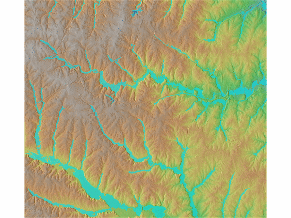
Figure: Inundation event 2 m.
Calculate series of inundation raster maps from a DEM raster map:
    r.hand -t elevation=elevation hand=hand inundation_strds=inundation_strds \
    start_water_level=0 end_water_level=5 water_level_step=1
Output HAND raster in addition to inundation raster(s):
    r.hand elevation=elevation hand=hand depth=4 threshold=5000 \
    inundation_raster=inundation
- 0 > HAND < 5 m = Surface Water Table
- 5 > HAND < 15 m = Shallow Water Table
- HAND > 15 m = Deep Water Table
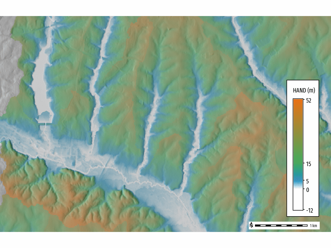
Figure: Height Above Nearest Drainage (HAND)
    # Reclassify HAND raster into categories
    r.reclass input=hand output=hand_reclass rules=- <$lt EOF
    -30000 thru 0 = NULL
    1 thru 5	= 1 Surface
    5 thru 15	= 2 Shallow
    15 thru 30000 = 3 Deep
    EOF

    # Set color table for HAND raster
    r.colors map=hand_reclass rules=- <$lt EOF
    1 #1d91c0
    2 #41ab5d
    3 #ec7014
    nv white
    default grey
    EOF
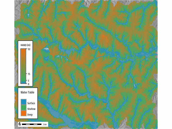
Figure: Height Above Nearest Drainage (HAND) water table classification.
REFERENCES
[1] Nobre, A.D., Cuartas, L.A., Hodnett, M., Rennó, C.D., Rodrigues, G., Silveira, A., Waterloo, M., Saleska, S., 2011. Height Above the Nearest Drainage – a hydrologically relevant new terrain model. Journal of Hydrology 404, 13–29. https://doi.org/10.1016/j.jhydrol.2011.03.051AUTHORS
Corey White, OpenPlains Inc. & NCSU GeoForAll Lab,Maris Nartiss (author of r.lake),
Vaclav Petras, NCSU GeoForAll Lab(author of r.lake.series)
SEE ALSO
r.watershed, r.lake, r.lake.seriesSOURCE CODE
Available at: r.hand source code (history)
Latest change: Tuesday Mar 04 09:58:40 2025 in commit: 66645d69a3b663f079a42fb1309c25f8125f538c
Main index | Raster index | Topics index | Keywords index | Graphical index | Full index
© 2003-2024 GRASS Development Team, GRASS GIS 8.3.3dev Reference Manual