NAME
v.clip - Extracts features of input map which overlay features of clip map.KEYWORDS
vector, clip, areaSYNOPSIS
Flags:
- -d
- Do not dissolve clip map
- -r
- Clip by region
- --overwrite
- Allow output files to overwrite existing files
- --help
- Print usage summary
- --verbose
- Verbose module output
- --quiet
- Quiet module output
- --ui
- Force launching GUI dialog
Parameters:
- input=name [required]
- Name of vector map to be clipped
- Or data source for direct OGR access
- clip=name [required]
- Name of clip vector map
- Or data source for direct OGR access
- output=name [required]
- Name for output vector map
Table of contents
DESCRIPTION
v.clip module enables extracting those features of input vector map, which overlay features of clip map, as well as their storing in a new vector map.In default, boundaries of clip map are dissolved before clipping. Alternatively, flag -d can be ticked to retain the boundaries of clip map. Flag -b facilitates clipping by current computational region.
It is possible to clip vector maps consisting of points, lines, areas or combinations of these. However, the current version does not fully support clipping of mixed geometry containing points. In such a case, the output map will only store clipped lines and/or areas.
NOTES
v.clip is a front-end to v.overlay, as well as v.select. Clipping of areas and/or lines can be achieved using v.overlay. Clipping of points can be performed with v.select.EXAMPLES
Basic use
Clip railroads by counties Wake and Johnston in North Carolina (North Carolina data set).v.extract input=boundary_county where="NAME='WAKE' OR NAME='JOHNSTON'" output=county_WAKE_JOHNSTON v.clip input=railroads clip=county_WAKE_JOHNSTON output=railroads_WAKE_JOHNSTON
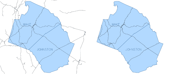
Figure: v.clip example - basic use
Retain boundaries of clip map
v.clip -d input=railroads clip=county_WAKE_JOHNSTON output=railroads_WAKE_JOHNSTON
Clip by current computational region
Clip hospitals by computational region adjusted to counties Wake and Johnston in North Carolina (North Carolina data set). It is not obligatory to enter name of clip map. In case it is stated, the clip map will be omitted.v.extract input=boundary_county where="NAME='WAKE' OR NAME='JOHNSTON'" output=county_WAKE_JOHNSTON v.clip -r input=hospitals output=hospitals_clip
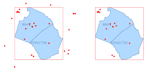
Figure: v.clip example - clip by computational region
SEE ALSO
v.overlay, v.select, v.dissolve, v.in.regionAUTHOR
Zofie Cimburova, GeoForAll Lab, Czech Technical University in Prague, Czech RepublicSOURCE CODE
Available at: v.clip source code (history)
Latest change: Thu Feb 3 11:10:06 2022 in commit: 73413160a81ed43e7a5ca0dc16f0b56e450e9fef
Main index | Vector index | Topics index | Keywords index | Graphical index | Full index
© 2003-2022 GRASS Development Team, GRASS GIS 8.0.3dev Reference Manual