NAME
v.centroids - Adds missing centroids to closed boundaries.KEYWORDS
vector, centroid, areaSYNOPSIS
Flags:
- --overwrite
- Allow output files to overwrite existing files
- --help
- Print usage summary
- --verbose
- Verbose module output
- --quiet
- Quiet module output
- --ui
- Force launching GUI dialog
Parameters:
- input=name [required]
- Name of input vector map
- Or data source for direct OGR access
- output=name [required]
- Name for output vector map
- option=string
- Action to be taken
- Options: add
- Default: add
- layer=string
- Layer number or name
- Vector features can have category values in different layers. This number determines which layer to use. When used with direct OGR access this is the layer name.
- Default: 1
- cat=integer
- Category number starting value
- Default: 1
- step=integer
- Category increment
- Default: 1
Table of contents
DESCRIPTION
GRASS defines vector areas as composite entities consisting of a set of closed boundaries and a centroid. The attribute information associated with that area is linked to the centroid. The v.centroids module adds centroids to closed boundaries in the input file and assigns a category number to them. The starting value as well as the increment size may be set using optional parameters.Multiple attributes may be linked to a single vector entity through numbered fields referred to as layers. Refer to v.category for more details, as v.centroids is simply a frontend to that module.
The boundary itself is often stored without any category reference as it can mark the border between two adjacent areas. Thus it would be ambiguous as to which feature the attribute would belong. In some cases it may, for example, represent a road between two parcels of land. In this case it is entirely appropriate for the boundary to contain category information.
EXAMPLES
Create an area from a closed line using North Carolina sample dataset:v.type input=busroute11 output=busroute11_boundary from_type=line to_type=boundary v.centroids input=busroute11_boundary output=busroute11_area
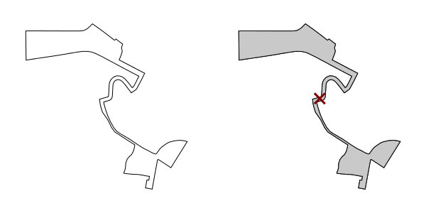
Figure: Creating area from closed line
SEE ALSO
v.categoryAUTHORS
module: M. Hamish Bowman, Dept. Marine Science, Otago University, New Zealandhelp page: Trevor Wiens
SOURCE CODE
Available at: v.centroids source code (history)
Latest change: Thu Feb 3 11:10:06 2022 in commit: 73413160a81ed43e7a5ca0dc16f0b56e450e9fef
Main index | Vector index | Topics index | Keywords index | Graphical index | Full index
© 2003-2022 GRASS Development Team, GRASS GIS 8.0.3dev Reference Manual