NAME
r.li.simpson - Calculates Simpson's diversity index on a raster mapKEYWORDS
raster, landscape structure analysis, diversity indexSYNOPSIS
r.li.simpson
r.li.simpson --helpr.li.simpson input=name config=name output=name [--overwrite] [--help] [--verbose] [--quiet] [--ui]
Flags:
- --overwrite
- Allow output files to overwrite existing files
- --help
- Print usage summary
- --verbose
- Verbose module output
- --quiet
- Quiet module output
- --ui
- Force launching GUI dialog
Parameters:
- input=name [required]
- Name of input raster map
- config=name [required]
- Configuration file
- output=name [required]
- Name for output raster map
Table of contents
DESCRIPTION
r.li.simpson calculates the "Simpson's diversity index" as: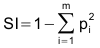
with:
- i: patch type
- m: number of different patch types
- pi: proportional abundance of patch type i
NOTES
Do not use absolute path names for the config and output file/map parameters. If the "moving window" method was selected in g.gui.rlisetup, then the output will be a raster map, otherwise an ASCII file will be generated in the folder C:\Users\userxy\AppData\Roaming\GRASS8\r.li\output\ (MS-Windows) or $HOME/.grass8/r.li/output/ (GNU/Linux).If the input raster map contains only NULL values then r.li.simpson returns NULL.
EXAMPLES
To calculate Simpson's diversity index on map my_map, using my_conf configuration file (previously defined with g.gui.rlisetup) and saving results in my_out, run:r.li.simpson input=my_map conf=my_conf output=my_out
Forest map (Spearfish sample dataset) example:
g.region raster=landcover.30m -p
r.mapcalc "forests = if(landcover.30m >= 41 && landcover.30m <= 43,1,null())"
r.li.simpson input=forests conf=movwindow7 out=forests_simpson_mov7
r.univar forests_simpson_mov7
Forest map (North Carolina sample dataset) example:
g.region raster=landclass96 -p
r.mapcalc "forests = if(landclass96 == 5, 1, null() )"
r.li.simpson input=forests conf=movwindow7 out=forests_simpson_mov7

# verify
r.univar forests_simpson_mov7
r.to.vect input=forests output=forests type=area
d.mon wx0
d.rast forests_simpson_mov7
d.vect forests type=boundary
SEE ALSO
r.li - package overviewg.gui.rlisetup
REFERENCES
McGarigal, K., and B. J. Marks. 1995. FRAGSTATS: spatial pattern analysis program for quantifying landscape structure. USDA For. Serv. Gen. Tech. Rep. PNW-351. (PDF)AUTHORS
Serena Pallecchi student of Computer Science University of Pisa (Italy).Commission from Faunalia Pontedera (PI), Italy (www.faunalia.it)
SOURCE CODE
Available at: r.li.simpson source code (history)
Latest change: Thu Feb 3 11:10:06 2022 in commit: 73413160a81ed43e7a5ca0dc16f0b56e450e9fef
Main index | Raster index | Topics index | Keywords index | Graphical index | Full index
© 2003-2022 GRASS Development Team, GRASS GIS 8.0.3dev Reference Manual