NAME
d.polar - Draws polar diagram of angle map such as aspect or flow directionsKEYWORDS
display, diagramSYNOPSIS
Flags:
- -x
- Plot using Xgraph
- --overwrite
- Allow output files to overwrite existing files
- --help
- Print usage summary
- --verbose
- Verbose module output
- --quiet
- Quiet module output
- --ui
- Force launching GUI dialog
Parameters:
- map=name [required]
- Name of raster angle map
- undef=float
- Pixel value to be interpreted as undefined (different from NULL)
- output=name
- Name for optional EPS output file
Table of contents
DESCRIPTION
d.polar calculates and displays a polar diagram of an angle raster map such as aspect, wind direction, or flow. The input angle map orientation must be counter-clockwise (CCW) from east, and the angle map units must be degrees. This refers to the standard orientation of GRASS (e.g., see r.slope.aspect).The radius of the outer circle is defined by the total number of pixels in the map. If the polar diagram does not reach the outer circle, no data (NULL) pixels were found in the map.
The vector in the diagram indicates a prevailing direction, its length the strength of such direction. In case all angle vectors are oriented along the same direction, the length for the vector is maximal (in fact it is equal to length of the most populated bin of the underlying histogram).
As a side effect, the quality of the angle map can be derived from the diagram. Strong spikes may indicate an over-representation of the related angle(s) which happens in particular if integer maps are used.
NOTES
If the output parameter is used, the diagram is generated as EPS file. If the -x flag is used xgraph is launched. Otherwise d.polar will use d.graph to draw the plot in the current display frame.If d.polar is used on an aspect map generated by r.slope.aspect, the undef parameter should be set to 0 to distinguish NO DATA (NULL) areas from areas where aspect is undefined (i.e. flat areas).
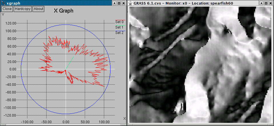
Polar diagram of aspect map
EXAMPLE
In this example, the polar diagram of the 'aspect' angle map in the North Carolina sample dataset location is generated:g.region raster=aspect -p d.polar aspect
XGRAPH REQUIREMENT
Xgraph must be installed for the -x flag to function.SEE ALSO
d.graph, d.histogram, d.rast.arrow, r.slope.aspectREFERENCES
J. Hofierka, H. Mitasova, and M. Neteler (2009): Terrain parameterization in GRASS. In T. Hengl and H.I. Reuter, editors, Geomorphometry: concepts, software, applications. Elsevier (DOI)AUTHORS
Markus Neteler, ITC-irst, ItalyBruno Caprile, ITC-irst, Italy
Hamish Bowman, Otago University, New Zealand
SOURCE CODE
Available at: d.polar source code (history)
Latest change: Thu Feb 3 11:10:06 2022 in commit: 73413160a81ed43e7a5ca0dc16f0b56e450e9fef
Main index | Display index | Topics index | Keywords index | Graphical index | Full index
© 2003-2022 GRASS Development Team, GRASS GIS 8.0.3dev Reference Manual